MapGO is a browser-based geospatial toolkit offering distance measurements, location hierarchy, GIS file conversion, and bulk CSV processing, with a free tier and REST API.
Get listed across 100+ startup directories, submitted by hand. Permanent dofollow backlinks and +25 domain rating on average.
Submit your website to get discovered by thousands of potential customers and boost your SEO.
Get ListedMapGO is a browser-based geospatial workspace that brings professional GIS capabilities to anyone with an internet connection. The platform covers the entire workflow—measuring distances, analyzing location hierarchies, converting between file formats, and visualizing data on an interactive map. For developers, it also offers a REST API accessible through RapidAPI, enabling automated geospatial enrichment. With a free tier that requires no credit card, MapGO lowers the barrier to entry for geographic data processing.
MapGO is organized around an interactive map and a set of tools that work together seamlessly.
Location Hierarchy — Clicking any point on the map returns a full administrative hierarchy: continent, country, region, and district. This reverse-geocoding function is based on MapGO's own dataset that includes 250+ countries and territories, millions of boundary points, and sub-region divisions. It is an instant way to understand the administrative context of any coordinate.
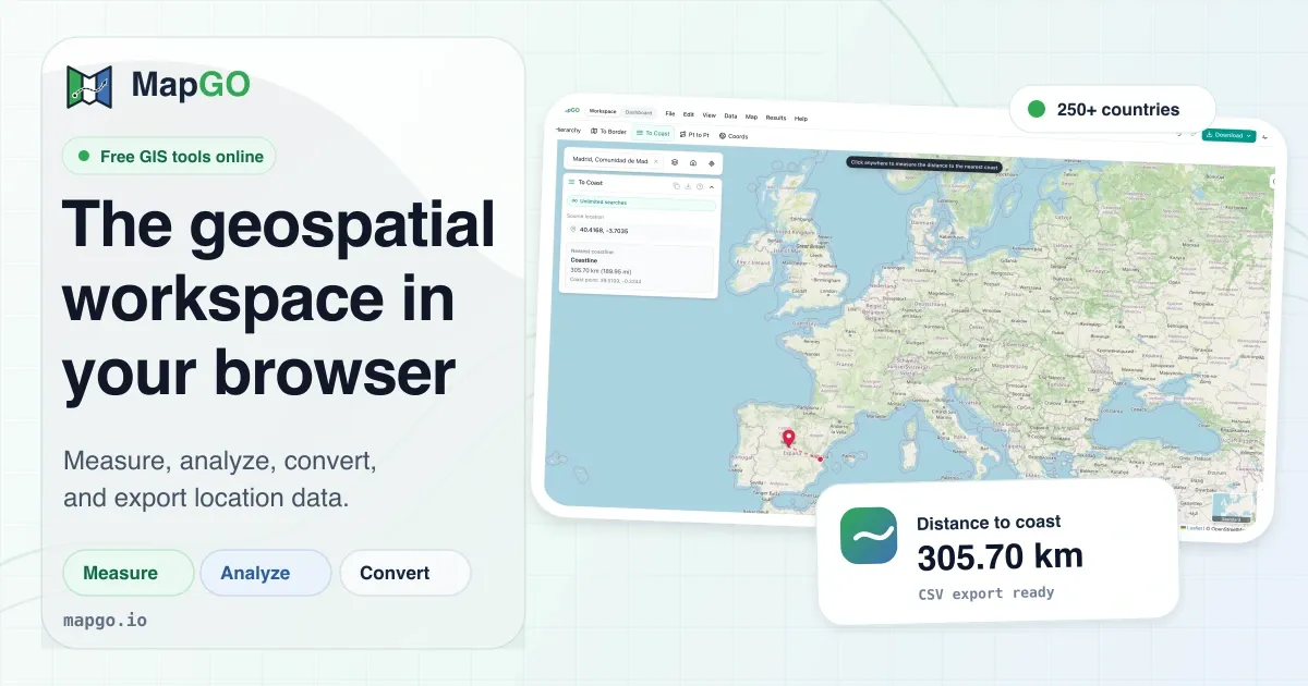
Distance to Border & Coastline — These two tools calculate the shortest straight-line distance from a selected point to the nearest land border or coastline. The calculations rely on high-resolution shapefiles developed in-house, which are more detailed than many public datasets. Users can see the result in kilometers or miles, and the map highlights the nearest boundary point.
Point-to-Point Distance — For planning or analysis, the platform measures the great-circle distance between two coordinates. The points can be dragged on the map, and the result updates live. This is useful for estimating travel distances, setting geofencing radii, or checking the span of a delivery area.
GPS Coordinate Converter — Converting between DD (decimal degrees), DMS (degrees-minutes-seconds), and DMM (degrees-decimal-minutes) is a common chore. MapGO provides a dedicated tool for this, which also works in reverse. Each coordinate format is clearly labeled, and the conversion happens instantly.
Measure & Draw Tools — The workspace includes a full set of map measurement utilities: distance, area, radius, and bearing. Users can draw polygons to calculate area, place a circle for radius, or measure the bearing between two points. The buffer tool generates buffer zones around features, and annotation tools allow custom shapes and labels. All measurements are interactive and update as the map is manipulated.
File Conversion — MapGO supports converting between GeoJSON, KML, GPX, Shapefile, and CSV. This is a major advantage for GIS professionals who frequently need to migrate between different software ecosystems. The conversion engine preserves geometry and attribute data as much as possible, and the output files are ready for use in other applications.
Bulk CSV Processing — Instead of querying one coordinate at a time, users can upload a CSV file with thousands of rows of latitude and longitude. MapGO processes the entire file in a single batch job, returning the enriched data (distance to border, coastline, hierarchy, etc.) in a downloadable CSV. This is a massive time-saver for data cleaning and enrichment tasks.
Developer API — MapGO exposes its functionality through a REST API hosted on RapidAPI. The API includes endpoints for full location responses, distance to border, distance to coastline, and coordinate conversion. With an API key, developers can integrate geospatial intelligence into their own applications without building the back-end infrastructure. The documentation includes sample code, such as the full-response-from-coordinates endpoint that returns a complete location profile for a given latitude/longitude.
The core experience begins in the MapGO workspace, where an interactive map fills the majority of the screen. Users can pan and zoom to any location, then click to place a marker. Immediately, the side panel populates with the administrative hierarchy and offers a set of action buttons for distance, border, coastline, and conversion tasks. Moving the marker recalculates every measurement in real-time.
For those who prefer to start with data, the convert tool accepts files in GeoJSON, KML, GPX, Shapefile, or CSV format. After uploading, the user selects the target format and downloads the converted file. The bulk CSV upload option is found in the workspace; it accepts a CSV with latitude and longitude columns and processes all rows in one go. The output CSV is appended with calculated distances and hierarchy data.
The API works differently. Developers sign up on RapidAPI, obtain an API key, and make HTTP requests to the MapGO endpoints. The example in the code block shows how to call the full-response endpoint for a coordinate near London, receiving hierarchy, border distance, and coastline distance in a single JSON response. This makes it trivial to enrich a user's coordinates with geographic context.
MapGO's combination of map interaction and batch processing suits a variety of professional scenarios:
MapGO is free to start. Without an account, users get five lookups per day. A free account—created simply with an email—raises the limit to ten lookups per day. For most evaluation purposes, that's sufficient to test the tools and API. The pricing page likely introduces subscription tiers for higher volume and bulk processing, though the exact prices are not listed on the landing page. Given that traditional GIS licensing is often expensive and complex, MapGO's web-based model is cost-effective for small teams and independent developers. The API is pay-as-you-go through RapidAPI, so integration costs scale with actual usage rather than upfront fees.
MapGO is a well-executed example of modern GIS simplification. It takes the most useful geospatial operations and packages them into a responsive, browser-based interface. The distance and hierarchy tools are fast and accurate thanks to high-resolution datasets. The file conversion feature alone can save GIS professionals hours of manual data wrangling. While the free tier has strict daily limits, they are enough for experimentation and small projects. MapGO is especially attractive for developers who need to add geographic context to their apps via the API, as it removes the need to self-host complex geocoding and distance services. For anyone who regularly deals with coordinates, MapGO is worth a try.